![]()

Muguriyarra and Benchmark Surveys have formed a strategic partnership built on years of successful collaboration across the Onslow and Pilbara regions.
This alliance is grounded in strong working relationships, shared values, and a commitment to reliable outcomes in remote and regional Western Australian conditions.
By combining Muguriyarra’s local knowledge, Indigenous leadership and workforce engagement—underpinned through its partnership with a wholly owned Thalanyji / Ngarluma Indigenous business—with Benchmark Surveys’ technical expertise, this partnership delivers stronger project outcomes, improved efficiency, and meaningful local participation.
We work respectfully on Country by recognising Traditional Owners, following cultural protocols, and supporting opportunities for local Aboriginal people through training, employment pathways and long‑term capability development.
Together, we are committed to supporting sustainable development, creating local opportunities, and delivering reliable, high‑quality surveying solutions across the Pilbara and beyond.
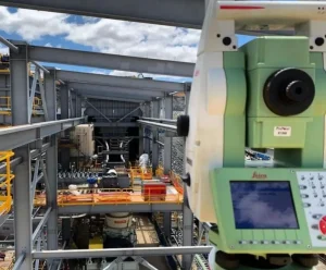
Our surveyors use the latest GPS, robotics, and reflector less Total Station technology. We combine the latest field equipment with the most powerful surveying and civil engineering software 12d Model along with Civil 3D to deliver the most efficient and fastest solutions to civil, road and bridge projects.
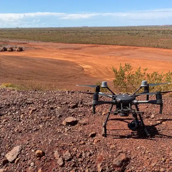
We have extensive experience in providing aerial survey services and flying Unmanned Aerial Vehicles (UAV) or drones as they are commonly referred to. We have a large fleet of fixed wing and rotary wing units and our surveyors are fully certified by Civil Aviation Safety Authority (CASA) to fly.
By pairing aerial photography with surveyed ground control points enables survey grade accuracy for all projects. Survey data is loaded into virtual surveyor and 12d Model to provide the most accurate digital data for your site. UAV can also capture areas that are difficult, hazardous, or completely inaccessible using conventional survey techniques. We are happy to advise you what the best approach is to meet your project’s quality, accuracy, time, and cost goals.
.
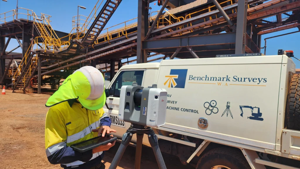
Laser Scanning is a powerful 3D imaging tool for surveyors. It has the advantage of full 3D capture of a desired area in x, y and Z coordinates without any physical contact. These scanners emit a laser beam that produces a 360-degree image scan with millions of points forming a point cloud. The speed of scanning and the density of points enables the most detailed 3D mapping of complex objects and landscapes. After the point clouds are captured, 3D modelling with meshing can be performed and extracted from the cloud.
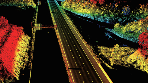
Capturing accurate survey, mapping and inspection data across infrastructure like roads and rail corridors presents a unique set of challenges. Survey teams must operate in environments with active traffic and other safety risks, cover long distances, and meet growing expectations for precise and highly detailed data collection.
We provide high-speed, high-accuracy mobile mapping for roads, infrastructure and large-scale assets. Using advanced vehicle-mounted LiDAR, cameras and GNSS/IMU positioning, we capture dense spatial data at traffic speed, delivering survey-grade results safely and efficiently.
Our mobile mapping system collects millions of points per second, producing accurate 3D models, digital twins and detailed asset information without disrupting operations.


SOA Airport Upgrade

Provision of Plants for TVI Rehabilitation

Mardie Miscellaneous Earthworks

SOA Overflow Caravan Park

MRL Ashburton Port Storage Facilities

SOA Airport Upgrade
NTC was awarded the airside upgrade works at the Onslow Airport. Theses works required NTC to undertake major runway and taxiway works in a live airport environment. The works included:
- Removal of an old Taxiway and full reconstruction of a replacement
- Profiling and Asphalting an old Taxiway to new profiles
- Installation of a Pavement Preservation Treatment
- Re-line marking of all runways and taxiways
- Removal and re-installation of a fuel resistant seal
- Batter repair and stabilisation including rock pitching
Undertaking major works around a live airport was a new scope for NTC to undertake. All works were managed to a defined Method of Works plan that was verified and approved by CASA.


Provision of Plants for TVI Rehabilitation
NTC was awarded the contract for the cultivation of over 120,000 native seedlings to be utilised in the rehabilitation of Thevenard Island. The works included:
- Collection of cuttings from Thevenard Island
- Cultivation of seeds and cuttings
- Hardening off of seedlings in Onslow
- Delivery to island transport
NTC Contracting engaged Workpower’s Wholesale Nursery and Environmental Services team to undertake the technical aspects of cuttings, propagation and support during the hardening off process.
Workpower employs people with disability who work alongside industry professionals, while our disability employment services support people to find and maintain employment in the open labour market.
For more information on the first delivery see below:
From propagation to planting, Thevenard Island sprouts – Workpower


Mardie Miscellaneous Earthworks
NTC was awarded the miscellaneous earthworks package to provide earthworks and general civil construction services to the huge Mardie Salt and Potash Project from the inception stage. The works included:
- Vacuum Excavation of holes around services
- Foundation Construction
- Sign Installation
- Roadwork Remediation
The initial works consisted of construction of heavily reinforced concrete slabs on top of 2 Santos and 1 Chevron Natural Gas Pipelines in a remote area of the site. NTC was responsible for the risk assessment process, earthworks, excavations for the slabs, steel works and concrete installation along with final roadworks. All works were undertaken through a heavily monitored permitting process with full time on site monitoring and supervision by both a Chevron and Santos Representative.

SOA Overflow Caravan Park
Muguriyarra was awarded the supply of resources for the Shire of Ashburton to construct an overflow caravan park adjacent to the previously renovated Ocean View Caravan Park by capability partner NTC. The works included:
- Bulk Earthworks
- Trim and Compact Subgrade
- Supply and cartage of Subbase Capping
- Placement and Compaction of Hardstand

MRL Ashburton Port Storage Facilities
Muguriyarra was awarded the contract for the Provision of Civil Works for the Ashburton Port Storage Facilities as part of the Onslow Iron Ore Project. Detailed earthworks are required in and around concrete piles and footings installed to support the huge Iron Ore Storage Facility for Mineral Resources. The works included:
- Detailed installation of Sand Subgrade
- Detailed installation of Select Fill and Basecourse
- Trimming of entire area to subgrade
- Asphalt sealing entire area